René's URL Explorer Experiment


Title: GeoTIFFs not correctly hidden on zoom out · Issue #40 · OpenMap-java/openmap · GitHub

Open Graph Title: GeoTIFFs not correctly hidden on zoom out · Issue #40 · OpenMap-java/openmap

X Title: GeoTIFFs not correctly hidden on zoom out · Issue #40 · OpenMap-java/openmap

Description: Hi, I posted about this on the mailing list maybe a year ago, but having encountered the problem again I thought I'd post on the issue tracker. When viewing GeoTIFF imagery on an ImageTileLayer, the images are only supposed to be display...

Open Graph Description: Hi, I posted about this on the mailing list maybe a year ago, but having encountered the problem again I thought I'd post on the issue tracker. When viewing GeoTIFF imagery on an ImageTileLayer, th...

X Description: Hi, I posted about this on the mailing list maybe a year ago, but having encountered the problem again I thought I'd post on the issue tracker. When viewing GeoTIFF imagery on an ImageTileLayer...

Opengraph URL: https://github.com/OpenMap-java/openmap/issues/40

X: @github

direct link

Domain: patch-diff.githubusercontent.com


Hey, it has json ld scripts:
{"@context":"https://schema.org","@type":"DiscussionForumPosting","headline":"GeoTIFFs not correctly hidden on zoom out","articleBody":"Hi,\r\n\r\nI posted about this on the mailing list maybe a year ago, but having encountered the problem again I thought I'd post on the issue tracker.\r\n\r\nWhen viewing GeoTIFF imagery on an ImageTileLayer, the images are only supposed to be displayed once you are zoomed in far enough. Once you zoom out past a certain level, a grey box is displayed instead, showing the geographical extent of the image. I assume at this point the image itself is supposed to be hidden, however, it continues being displayed at the same on-screen pixel size that it was before zooming out. The result is that you get a false impression of the geographical size of the image, where it appears much bigger geographically than it really is. The following image illustrates the problem:\r\n\r\n![Example](https://raw.githubusercontent.com/ianrenton/storage/master/SnipImage.JPG?raw=true)
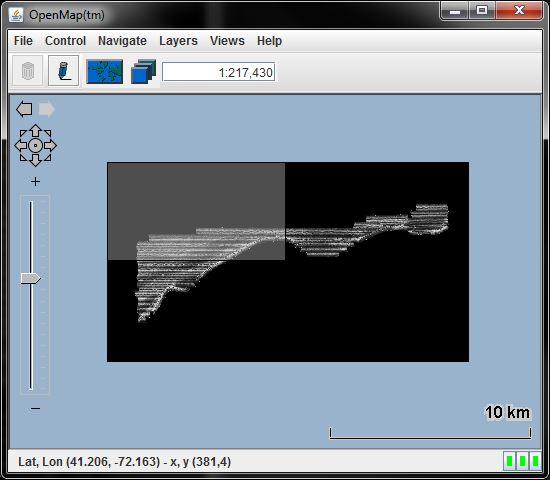
\r\n\r\nSteps to reproduce:\r\n\r\n1. Using OpenMap 5.1.15, include the JAI JARs and static libraries required for GeoTIFF display on the path/classpath\r\n2. Add an `ImageTileLayer`, e.g. in `openmap.properties`:\r\n````\r\nopenmap.layers=(...) geotiff\r\nopenmap.startUpLayers=(...) geotiff\r\ngeotiff.class=com.bbn.openmap.layer.imageTile.ImageTileLayer\r\ngeotiff.prettyName=GeoTiffs\r\n````\r\n3. Run OpenMap\r\n4. Edit the ImageTile layer, click Add and locate a GeoTIFF file (see below for example).\r\n5. Once the file appears in the list, select it and click \"Go To\" to zoom to the location of the GeoTIFF at its best-fit size\r\n6. Zoom out at least twice using the on-screen \"-\" button.\r\n\r\nI have also encountered the issue using programmatically created `ImageTile`s, so I am wondering if the issue is somewhere around `ImageTile`'s `updateImageForProjection()` / `shouldFetchForProjection()` methods, but I can't see an obvious path by which it could display both the image and the grey box. Is it maybe keeping the image graphic in the layer's graphic list and not removing it when the projection no longer requires it to be rendered?\r\n\r\n(I have uploaded an [example GeoTIFF file here](https://github.com/ianrenton/storage/blob/master/h11446_sss1m_latlong.zip?raw=true) for you to try if you don't have a suitable file. The image was converted for OpenMap from the US government open data set [available here](http://pubs.usgs.gov/of/2010/1100/data/sidescan/utm/h11446_sss1m_utm.zip).)","author":{"url":"https://github.com/ianrenton","@type":"Person","name":"ianrenton"},"datePublished":"2017-08-15T09:15:18.000Z","interactionStatistic":{"@type":"InteractionCounter","interactionType":"https://schema.org/CommentAction","userInteractionCount":1},"url":"https://github.com/40/openmap/issues/40"}

route-pattern/_view_fragments/issues/show/:user_id/:repository/:id/issue_layout(.:format)
route-controllervoltron_issues_fragments
route-actionissue_layout
fetch-noncev2:36c2194a-9092-b4d3-9941-5cd82fc35eac
current-catalog-service-hash81bb79d38c15960b92d99bca9288a9108c7a47b18f2423d0f6438c5b7bcd2114
request-idBD42:110A09:2F17C4:3F15B6:6980F5EA
html-safe-nonce9db33fca4026ce514b472c0161b8460c87087e2720c3835d3f7fac38da1ee1ff
visitor-payloadeyJyZWZlcnJlciI6IiIsInJlcXVlc3RfaWQiOiJCRDQyOjExMEEwOToyRjE3QzQ6M0YxNUI2OjY5ODBGNUVBIiwidmlzaXRvcl9pZCI6IjQxNjcxMTU4OTI0MTg3Mzc2NDIiLCJyZWdpb25fZWRnZSI6ImlhZCIsInJlZ2lvbl9yZW5kZXIiOiJpYWQifQ==
visitor-hmac27dc93194234e84c68955e4bb06cd80f846a8cc4576bbb77a3dcd0486787f18f
hovercard-subject-tagissue:250262874
github-keyboard-shortcutsrepository,issues,copilot
google-site-verificationApib7-x98H0j5cPqHWwSMm6dNU4GmODRoqxLiDzdx9I
octolytics-urlhttps://collector.github.com/github/collect
analytics-location///voltron/issues_fragments/issue_layout
fb:app_id1401488693436528
apple-itunes-appapp-id=1477376905, app-argument=https://github.com/_view_fragments/issues/show/OpenMap-java/openmap/40/issue_layout
twitter:imagehttps://opengraph.githubassets.com/74a0162b69b5773bbb76472beb4ee2296766937dd2a3a2d2b480ebeef7219835/OpenMap-java/openmap/issues/40
twitter:cardsummary_large_image
og:imagehttps://opengraph.githubassets.com/74a0162b69b5773bbb76472beb4ee2296766937dd2a3a2d2b480ebeef7219835/OpenMap-java/openmap/issues/40
og:image:altHi, I posted about this on the mailing list maybe a year ago, but having encountered the problem again I thought I'd post on the issue tracker. When viewing GeoTIFF imagery on an ImageTileLayer, th...
og:image:width1200
og:image:height600
og:site_nameGitHub
og:typeobject
og:author:usernameianrenton
hostnamegithub.com
expected-hostnamegithub.com
None39fe8101494cbb823c09b619b68c80cd4d05ab7279997038dbe06bb91608abe1
turbo-cache-controlno-preview
go-importgithub.com/OpenMap-java/openmap git https://github.com/OpenMap-java/openmap.git
octolytics-dimension-user_id13439710
octolytics-dimension-user_loginOpenMap-java
octolytics-dimension-repository_id40129738
octolytics-dimension-repository_nwoOpenMap-java/openmap
octolytics-dimension-repository_publictrue
octolytics-dimension-repository_is_forkfalse
octolytics-dimension-repository_network_root_id40129738
octolytics-dimension-repository_network_root_nwoOpenMap-java/openmap
turbo-body-classeslogged-out env-production page-responsive
disable-turbofalse
browser-stats-urlhttps://api.github.com/_private/browser/stats
browser-errors-urlhttps://api.github.com/_private/browser/errors
released5b34a4e4898b066c629879feb4b184bc471d6a7
ui-targetfull
theme-color#1e2327
color-schemelight dark

Links:

Skip to contenthttps://patch-diff.githubusercontent.com/OpenMap-java/openmap/issues/40#start-of-content
https://patch-diff.githubusercontent.com/
Sign in https://patch-diff.githubusercontent.com/login?return_to=https%3A%2F%2Fgithub.com%2FOpenMap-java%2Fopenmap%2Fissues%2F40
GitHub CopilotWrite better code with AIhttps://github.com/features/copilot
GitHub SparkBuild and deploy intelligent appshttps://github.com/features/spark
GitHub ModelsManage and compare promptshttps://github.com/features/models
MCP RegistryNewIntegrate external toolshttps://github.com/mcp
ActionsAutomate any workflowhttps://github.com/features/actions
CodespacesInstant dev environmentshttps://github.com/features/codespaces
IssuesPlan and track workhttps://github.com/features/issues
Code ReviewManage code changeshttps://github.com/features/code-review
GitHub Advanced SecurityFind and fix vulnerabilitieshttps://github.com/security/advanced-security
Code securitySecure your code as you buildhttps://github.com/security/advanced-security/code-security
Secret protectionStop leaks before they starthttps://github.com/security/advanced-security/secret-protection
Why GitHubhttps://github.com/why-github
Documentationhttps://docs.github.com
Bloghttps://github.blog
Changeloghttps://github.blog/changelog
Marketplacehttps://github.com/marketplace
View all featureshttps://github.com/features
Enterpriseshttps://github.com/enterprise
Small and medium teamshttps://github.com/team
Startupshttps://github.com/enterprise/startups
Nonprofitshttps://github.com/solutions/industry/nonprofits
App Modernizationhttps://github.com/solutions/use-case/app-modernization
DevSecOpshttps://github.com/solutions/use-case/devsecops
DevOpshttps://github.com/solutions/use-case/devops
CI/CDhttps://github.com/solutions/use-case/ci-cd
View all use caseshttps://github.com/solutions/use-case
Healthcarehttps://github.com/solutions/industry/healthcare
Financial serviceshttps://github.com/solutions/industry/financial-services
Manufacturinghttps://github.com/solutions/industry/manufacturing
Governmenthttps://github.com/solutions/industry/government
View all industrieshttps://github.com/solutions/industry
View all solutionshttps://github.com/solutions
AIhttps://github.com/resources/articles?topic=ai
Software Developmenthttps://github.com/resources/articles?topic=software-development
DevOpshttps://github.com/resources/articles?topic=devops
Securityhttps://github.com/resources/articles?topic=security
View all topicshttps://github.com/resources/articles
Customer storieshttps://github.com/customer-stories
Events & webinarshttps://github.com/resources/events
Ebooks & reportshttps://github.com/resources/whitepapers
Business insightshttps://github.com/solutions/executive-insights
GitHub Skillshttps://skills.github.com
Documentationhttps://docs.github.com
Customer supporthttps://support.github.com
Community forumhttps://github.com/orgs/community/discussions
Trust centerhttps://github.com/trust-center
Partnershttps://github.com/partners
GitHub SponsorsFund open source developershttps://github.com/sponsors
Security Labhttps://securitylab.github.com
Maintainer Communityhttps://maintainers.github.com
Acceleratorhttps://github.com/accelerator
Archive Programhttps://archiveprogram.github.com
Topicshttps://github.com/topics
Trendinghttps://github.com/trending
Collectionshttps://github.com/collections
Enterprise platformAI-powered developer platformhttps://github.com/enterprise
GitHub Advanced SecurityEnterprise-grade security featureshttps://github.com/security/advanced-security
Copilot for BusinessEnterprise-grade AI featureshttps://github.com/features/copilot/copilot-business
Premium SupportEnterprise-grade 24/7 supporthttps://github.com/premium-support
Pricinghttps://github.com/pricing
Search syntax tipshttps://docs.github.com/search-github/github-code-search/understanding-github-code-search-syntax
documentationhttps://docs.github.com/search-github/github-code-search/understanding-github-code-search-syntax
Sign in https://patch-diff.githubusercontent.com/login?return_to=https%3A%2F%2Fgithub.com%2FOpenMap-java%2Fopenmap%2Fissues%2F40
Sign up https://patch-diff.githubusercontent.com/signup?ref_cta=Sign+up&ref_loc=header+logged+out&ref_page=%2F%3Cuser-name%3E%2F%3Crepo-name%3E%2Fvoltron%2Fissues_fragments%2Fissue_layout&source=header-repo&source_repo=OpenMap-java%2Fopenmap
Reloadhttps://patch-diff.githubusercontent.com/OpenMap-java/openmap/issues/40
OpenMap-java https://patch-diff.githubusercontent.com/OpenMap-java
openmaphttps://patch-diff.githubusercontent.com/OpenMap-java/openmap
Notifications https://patch-diff.githubusercontent.com/login?return_to=%2FOpenMap-java%2Fopenmap
Fork 49 https://patch-diff.githubusercontent.com/login?return_to=%2FOpenMap-java%2Fopenmap
Star 79 https://patch-diff.githubusercontent.com/login?return_to=%2FOpenMap-java%2Fopenmap
Code https://patch-diff.githubusercontent.com/OpenMap-java/openmap
Issues 26 https://patch-diff.githubusercontent.com/OpenMap-java/openmap/issues
Pull requests 11 https://patch-diff.githubusercontent.com/OpenMap-java/openmap/pulls
Actions https://patch-diff.githubusercontent.com/OpenMap-java/openmap/actions
Projects 0 https://patch-diff.githubusercontent.com/OpenMap-java/openmap/projects
Wiki https://patch-diff.githubusercontent.com/OpenMap-java/openmap/wiki
Security 0 https://patch-diff.githubusercontent.com/OpenMap-java/openmap/security
Insights https://patch-diff.githubusercontent.com/OpenMap-java/openmap/pulse
Code https://patch-diff.githubusercontent.com/OpenMap-java/openmap
Issues https://patch-diff.githubusercontent.com/OpenMap-java/openmap/issues
Pull requests https://patch-diff.githubusercontent.com/OpenMap-java/openmap/pulls
Actions https://patch-diff.githubusercontent.com/OpenMap-java/openmap/actions
Projects https://patch-diff.githubusercontent.com/OpenMap-java/openmap/projects
Wiki https://patch-diff.githubusercontent.com/OpenMap-java/openmap/wiki
Security https://patch-diff.githubusercontent.com/OpenMap-java/openmap/security
Insights https://patch-diff.githubusercontent.com/OpenMap-java/openmap/pulse
New issuehttps://patch-diff.githubusercontent.com/login?return_to=https://github.com/OpenMap-java/openmap/issues/40
GeoTIFFs not correctly hidden on zoom outhttps://patch-diff.githubusercontent.com/OpenMap-java/openmap/issues/40#top
https://github.com/ianrenton
ianrentonhttps://github.com/ianrenton
on Aug 15, 2017https://github.com/OpenMap-java/openmap/issues/40#issue-250262874
https://raw.githubusercontent.com/ianrenton/storage/master/SnipImage.JPG?raw=true
example GeoTIFF file herehttps://github.com/ianrenton/storage/blob/master/h11446_sss1m_latlong.zip?raw=true
available herehttp://pubs.usgs.gov/of/2010/1100/data/sidescan/utm/h11446_sss1m_utm.zip
https://github.com
Termshttps://docs.github.com/site-policy/github-terms/github-terms-of-service
Privacyhttps://docs.github.com/site-policy/privacy-policies/github-privacy-statement
Securityhttps://github.com/security
Statushttps://www.githubstatus.com/
Communityhttps://github.community/
Docshttps://docs.github.com/
Contacthttps://support.github.com?tags=dotcom-footer

Viewport: width=device-width


URLs of crawlers that visited me.